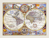
1821 Cary Map of Part of the United States Art Print


Brandywine General Store
An Art Print of the 1821 Map of Part of the United States by John Cary published for the New Universal Atlas for sale by Brandywine General Store. This map includes numerous references to the American Indian nations occupying the region, including the Chippewa, the Ottawa, and the Six Nations. Immense Forest and Hunting Country are some of the more archaic terms also used. The “Indian Boundary” is shown bisecting the North West Territory. Created by General Wayne’s treaty of 1795, this boundary line proposed to denotes the southern limit of American Indian lands in the North Western Territory.States. This map includes the states of New York, Vermont, New Hampshire, Massachusetts, Connecticut, Rhode Island, Pennsylvania, New Jersey, Delaware, Maryland and Virginia. Picture #56 an archival premium quality cartography artwork of early America.
Our Products