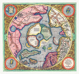
1626 A New and Accurate Map of the World by John Speed


Brandywine General Store
An art Print of the 1626 New and Accurate Map of the World by John Speed for sale by Brandywine General Store. This desirable double hemisphere world map is dated 1626 but was known to be published through 1632 with the same imprint. This is considered one of the earliest world maps to be published in the English language and is the first atlas map to show the cartographic blooper of California as an island, this myth persisted and drawn on different maps for over a century. This was also one of the first maps to show the settlement of New Plymouth. The coastline of North America is blank to the east of California and swings wildly to the west in the northern regions of Canada and Alaska. The Southern Unknown Lands shows the large conjectured continent covering much of the southern hemisphere. This map is beautifully engraved and highly detailed throughout. The engraver is unknown but was most likely Abraham Goos. The highly decorative car-touches include two celestial hemispheres, figural allegorical representations of Water, Earth, Air and Fire plus portraits of Ferdinand Magellan, Oliver Vander Noort, Thomas Cavendish and Sir Francis Drake. The corners are filled with an astronomical table, an armillary sphere and eclipses of the sun and moon. There are several lengthy notes including comments on the South Pole and the Straights of Magellan, Sir Francis Drake and more. This original map was not circulated as heavily as the maps by the Dutch cartographers and was not common outside of the United Kingdom, therefore it is rare today. Picture #09 a premium archival cartography map print

Our Products