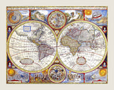
1635 Blaeu Americae Nova Tabula Cartography Print


Brandywine General Store
An art Print of Willem Janszoon Blaeu antique map of Americae Nova Tabula made around 1635 for sale by Brandywine General Store. We were able to redo most of the colors on this antique cartography artwork, so around 80 to 90% of the faults have been removed, leaving a very nice looking print. This much sought after map shows much detail throughout including a classic portrayal of the West Coast of the future United States, which doesn't show California as an island, dozens of place names along the Eastern Coast are listed, this area was just being settled. Across the top are nine views of important cities and harbors of the Americas while along both sides are ten panels of Native Americans of various regions throughout the Americas, shown in their Native dress. The map is also embellished with eight sailing ships, four sea monsters and vignettes of the interior of the continent showing Indian Life. The small inset map shows Greenland and Iceland and narrow parts of the coasts of Spain and Africa are shown on the right. European Geographers still had no knowledge of the extent of the Mississippi River. From the journals of DeSoto during the years of 1539 - 1543, they knew an extensive range of east to west trending mountains existed north of the Gulf of Mexico, but without any great river system. The Great Lakes were still undiscovered. The English names on the East Coast were given by the Roanoke colonists in VA. Picture #14 an archival antique cartography print

Our Products