1730 Stoopendal World Map Art Print


Brandywine General Store
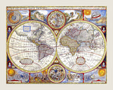
An Art Print of the 1730 Stoopendal World Map drawn by Daniel Stoopendaal for the Keur Bible for sale by Brandywine General Store. Stoopendaal, in this map made during the 18th century, is still portraying California as an island and the Great Lakes are still one big body of water, but both of these misconceptions would soon be remedied in a few more years. He also was still naming the mythical kingdoms of El Dorado and others in South America. Africa, like North and South America was well mapped on the borders with the ocean, but still largely unexplored in the interior. Asia Minor is fairly accurately mapped as is of course, Europe. Daniel Stoopendaal lived from 1672 to 1726 and was a Dutch engraver and mapmaker active in Amsterdam during the early part of the 17th century. His most famous cartographic work was his remakes of the Visscher maps of the Holy Land for inclusion in the Keur Bible. This map is surrounded by beautiful colorful cartouches and in the center at the bottom and the top is a chart showing the orbits of the planets around the sun up through Saturn. As this was all the planets that had been discovered at this time. They also show the orbit of the moon around the planet Earth. Picture #07 an archival premium cartography print by Brandywine General Store.
Our Products