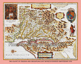
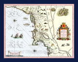
1630 Map of Virginia & Chesapeake by Henricus Hondius
A Museum Quality Print of the Historical 1630 Map of the Colony of Virginia and Chesapeake Bay which is oriented to the west instead of east as most maps are, for sale by Brandywine General Store. This early New World map was originally drawn by Henricus Hondius and published in Amsterdam. The territory covered in this map extends from Cape Henry to the Susquehanna River and inland as far as the Appalachian Mountains, even though most of the interior of Virginia was still uncharted, explaining why there are several mountain ranges shown where in fact there are none. Cartographically this map is based upon John Smith's landmark map of the Virginia colony which was issued in 1612. Smith's fine survey work, as well as reports from the indigenous Indian tribes and wishful thinking, combine to make this a very interesting and historical map. The car touche on the left shows Chief Powhatan, the father of Pocahontas, setting enthroned before a big fire in his longhouse. Of course, the legend is that when Smith was captured by Powhatan, the Indian Chief's young daughter, Pocahontas fell in love with John Smith and saved him. But it might be that Powhatan wanted the English help to defeat the neighboring Indian tribes such as the Masawomecks. who are shown on the right side of the map, which was about at the headwaters of the Potomac river. A great historical map showing Indian tribes in the early colony of Virginia. Picture #03 a premium, archival cartography print by Brandywine General Store.


