1799 World Map with Captain Cook's Voyages Art Print


Brandywine General Store
$9.99
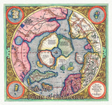
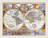
A Museum Quality Art Print of the 1799 World Map with the Voyages of Captain Cook for sale by Brandywine General Store. A new map of the World with all the new discoveries by Captain Cook and other navigators, Ornamented with the Solar System with the Eclipses of the Sun, Moon and Planets by T. Kitchin, Geographer London, 1799. This Kitchin map shows the World as a double hemisphere and has all the voyages of Captain Cook drawn in on the map. The outer coasts of the New Americas are fully named and labelled, but be advised that on smaller sizes of this map, the printing is hard to read as it was originally printed small. There are several oceans listed namely The Pacific or Great South Sea, The Western or Atlantic Ocean, South Pacific Ocean, Southern Icy Ocean, The Aethiopic Ocean and The Eastern Ocean and Eastern Sea, North Pacific Ocean and the Northern Icy Ocean. I believe this was originally published in two sheets in an atlas which you can see the splice in the middle of the map. Picture #08
Our Products